

Sign In Join Free


1 / 1
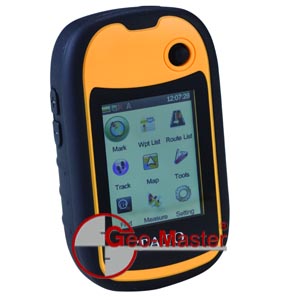
Surveying Equipment GPS Equipment Hand-Held GPS Receiver (E10)
| Model No. : | E10 |
|---|


Product description
Features
- Software Characteristics
Equipped with professional navigation measuring software, E series have rich contents to display. Users can check the location, power, satellite states and menu. After analyzing the GPS data, the real-time location can be displayed on the background. Then users are able to check the information of longitude and latitude as well as the satellite distribution.
- Data Acquisition
Strong measuring function, which makes the waypoint positioning and track measurement more convenient.
- Area Measurement
This function enables users to calculate the route length shown on the screen. Users can choose the perimeter and area and define features as well as property. The flexible measurement method suits for different measuring object, effectively improving the accuracy of measurement.
- Easy Operation
With a function key and user-friendly interface, it is easy to understand and convenient to use. E series are lightweight and compact, perfect for all kinds of usage. The large TFT Transflective Display allows for usage even in bright daylight.
- Three-prevention
As professional hand-held excellent and durable performance, E series are built to IPX7 specification, which will enable you to continue working in the extreme conditions.
- Wide Applications
Mining, Electricity, Transformation, Forestry, Agriculture, Communications, Environment, Mapping, Oil/Gas, Earthquake, Insurance, Travel, Public safety
- Map uploading and/or downloading
N/A for the time being!
- Reception Function
1)Receiver: 20 channels;GPS: High sensitive Chip (it can position even in forests or canyons)
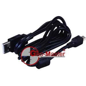
2) Interface: USB, NMEA0183 output available
3) Waterproof: IPX7
4) Free drop: 1.5 M on concrete
5) Positioning time: 10s (hot start), 40s (warm start), 60s ( cold start)
-Navigation Function
1) Data Record: waypoints: 3000; routes: 60; tracks: 20; each track up to 10000 way points
2) Coordinate System: 5 different kinds of coordinate systems can be viewed at the same time
3) Area measurement: Track measurement+Route Measurement
4) Navigation Methode: straight-line routing
- Physical Characteristics
1) Display: 2.4",color transflective TFT LCD,touch-screen
2) Pixels: 320×240
3) Size:105mm×58mm×26mm; Size w.Inner Box:112mm×68mm×37mm
4) Keyboard: 4-way navigation
5) Memory Card: E10: microSDHC
6) Sensor: 3-axis electronic compass and barometric altimeter (available with E30)
7) Working Temperature: -20~60°C
8) Operating Temperature: 0~60°C
- Power Supply
1)Optional: Alkaline Battery: 2 x AA (1.5V) or Li-ion battery
2) Battery Life: >8 hours (AA);> 12 hours (Li-ion battery)
- Standard Cccessories
Strap, Lock Catch, User Manual
- Optional Accessories
Li-ion Battery, Charger,Data Transfer Cable(NMEA183 output)
- Packing Info per Shipping Carton
Qty: 8pcs; G.W.: 4kg; Size: 0.033cbm (50cm×35cm×19cm)
N.B.: The above specifications would be subject to change without prior notice!
Send your inquiry to this supplier
Product Alert
Subscribe to your interested keywords. We will send freely the latest and hottest products to your Inbox. Don't miss any trade information.
Your use of this website constitutes acknowledgement and acceptance of our Terms & Conditions.
Copyright © 2009-2024 Bossgoo Co., Ltd. All rights reserved.
